
1. Introduction
In 2022, a book titled Blue Homeland, A Book of a Map and a Doctrine: Türkiye’s National Pact on the Seas, (Mavi Vatan, Bir Harita ve Bir Doktrin Kitabı: Türkiye’nin Denizlerdeki Misak-ı Millî’si) was published by the Istanbul University Press (Yaycı, 2022). The same book was republished with the same title in November 2024 by the Turkish Historical Society (Türk Tarih Kurumu), the state institution that has produced official historical theses of Turkey since its foundation in the 1930s.[1] The term National Pact (Misak-ı Millî) is not mentioned or discussed again in the book aside from its title. In other words, it lacks direct analysis of the reasons for the Blue Homeland (Mavi Vatan) doctrine’s formation as the National Pact on the Seas. Rather, it examines the theses of Turkey focusing on the problematic issues, such as the continental shelf or the gray zones, in the Aegean Sea. However, the map on the cover of the book, while seeming to have solved the problems regarding maritime jurisdiction, implies a new geographical imagination for Turkey, somehow tying a century-old document or a legitimizing concept related to the boundaries of Turkey to recent Turkish foreign policy in the Eastern Mediterranean. In other words, it implies a cartographic claim despite its actual emphasis on the maritime zones instead of borders.
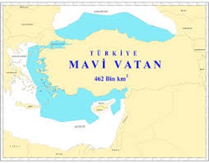
Figure 1 Blue Homeland was not the first map or discourse in Turkish foreign policy that was associated with the National Pact. As will be anticipated based on the narrative of this article, it will probably not be the last one.
This study aims to examine the utilization of the National Pact in Turkish foreign policy in different periods, with several emphases. First and foremost, this article underlines that the National Pact has never turned into a mere historical document as it has constituted one of the most important reference points, in other words, historical narratives, for the much discussed—and still being discussed—boundaries of Turkey. In other words, it has been relevant for Turkish foreign policy discourses and a legitimizing factor for the discussions of the boundaries in most of the Republican era. Second, as the Pact was contentious, or not clearly delineated even in the period that was declared, so was its use in foreign policy—and in public discussions too. The “national” borders—where they start and end, whom they include or exclude—have changed from one sub-period to another according to the necessities of the time and to the aims of Turkish foreign policy.
In this regard, this article examines the National Pact as a key concept for the formation of the Turkish geo-body, or the spatial representation of the nation, on the one hand. On the other hand, it argues that the Pact creates alternative maps for Turkey in most of the Republican era, though substitute uses of the term reflect cartographic anxieties of the country. This article utilizes a dual framework for the term “cartographic anxiety.” Anxiety has a component of fear, or alarm for territorial loss in other words, emphasizing the territorial integrity of the country. However, it also implies territorial ambitions that turn the National Pact into an instrument for legitimizing Turkish aims, if any, on the former Ottoman geographies that remained outside of the territories of the Republic that were formed in the aftermath of World War I. Fear and ambition have sometimes cooperated with each other in foreign policy. All in all, the maps that were produced and re-produced based on the National Pact have not only constituted alternative geographical visualizations or imaginations of Turkey but also reflected cartographic anxiety of the country.
Based on these assumptions, this article first aims to constitute a conceptual framework for the use of the National Pact in the next section. It briefly puts forward a scholarly debate on the meaning of geo-body as well as cartographic anxiety, regarding both the fear and ambition in foreign policy that this article relates to the National Pact in the Turkish case. Thereafter, it engages with the formation of the National Pact during the era of the Turkish National Struggle (Millî Mücadele). After emphasizing the vague nature of the National Pact on the boundaries of Turkey, it looks at examples that put it at the forefront in Turkish foreign policy within the Republican era, also showing that it has been a legitimizing discourse for the concerns and aims of Turkish foreign policy.
2. A Conceptual Framework for the Use of the National Pact: The Notions of Geo-body and Cartographic Anxiety
Until the last decades of the 20th century, the common understanding about cartography was scientific, implying that the discipline solely depicts objective truth or knowledge. The declining influence of positivist thinking in many disciplines also had an impact on cartography when scholars started to question the underlying meanings of maps beyond the assumption that they are showing objective truth. It has been increasingly acknowledged that maps reflect power processes and politics influence content and context for cartography (Black, 1997, p.28). This idea closely relates to the understanding that although maps can show reality in many ways, they can also distort this reality as they have a function and purpose (Kreiner et al., 2006, p.382). After all, maps usually carry a message, aim to influence the audience, manifest power relations, and become a means for political objectives.
While performing these actions, maps also connect the discipline of International Relations (IR) to cartography through different concepts. For example, “boundaries,” which constitute a central subject in political cartography, are strictly connected to the concept of sovereignty that is supposedly practiced by states on a clearly defined territory (see Jones, 2012). The relationship between the boundaries and territorial sovereignty of a state reflects the above-mentioned interaction between the disciplines of cartography and IR, which has taken the notion of state sovereignty for granted as a unit of analysis (Newman & Paasi, 1998, p.187) since the formation of modern international order. To be more specific, as the medium of cartography, maps visualize sovereign states in the international order. In the age of nationalism, the notion of boundaries would also be discussed together with the idea of “nation.” The proper boundaries are assumed to be so significant “for a map of a nation that the latter cannot exist without the former” (Winichakul, 1994, pp.55-56). Therefore, in the age of modernity, states on maps with clearly demarcated boundaries have a sovereignty claim on both territory and nation. Modern maps, while creating a shape for a country, turn into a medium for nation-building. This phenomenon is exemplified by the term “geo-body,” coined by Winichakul to indicate the spatial definition of a nation through maps (Winichakul, 1994). In this sense, the geo-body of a nation refers to “a man-made territorial definition which creates effects…on people, things and relationships” (Winichakul, 1994, p.17). The narratives around the National Pact have related not only to the cartographic shape of Turkey but also to the definition of the Turkish nation that includes and excludes people, things, and relationships. In other words, these narratives get involved in a discussion about the geo-body of the Turkish nation.
However, the emergence of states with exact boundaries and objective of nationhood has never been easy. In many cases, territorial ruptures largely due to wars, revolutions, colonial assertions, or anti-colonial movements and imperial collapses are involved (Short, 2022, pp.32-33). These ruptures reflect upon cartography in two ways. First, it creates questions about the proper shape of a country. It should be noted that answers to these questions concern both foreign and domestic politics. For example, Callahan (2009) examines the Chinese “maps of national humiliation” of the 1930s that depict areas lost to Western powers and Japan. While these maps produced by the state illustrated an era of shame, they simultaneously claimed these lost territories, making them aspirational. In any case, the Chinese example included a struggle on the question of cartographic shape that would be negotiated not only with foreign powers but also within the country itself given that there were different visions for the borders of China that were in competition with each other (Callahan, 2009, p.145). The discussion on the National Pact in Turkey is parallel to the Chinese case. The territorial shape of the Turkish Republic, which was formed as a result of a simultaneous anti-colonial struggle and imperial collapse, was discussed through the National Pact, yet in a textual way. Although this was a declaration aimed at the European powers, it started a debate in the domestic sphere from the start. As will be shown, there is still an ongoing public discussion regarding which areas to include or exclude in Turkey’s territory. The cases made in this regard are sometimes supported or refuted with maps. These discussions also have alternative projections for nationhood, which classifies them as debates about the Turkish geo-body.
The second reflection is the condition of “cartographic anxiety.” The term was first coined by the geographer Derek Gregory to refer to a theoretical concern about knowing and representing the world in an objective manner (Gregory, 1994). In the same year, it was almost simultaneously used by Sankaran Krishna to describe India’s constant feeling of “anxiety” about its borders, largely based on the division that took place in 1947, resulting in various methods employed to keep the body-politic of the nation intact (Krishna, 1994). Although the term targeted India in specific, it was later used by many scholars to understand different contexts. As Billé rightly suggests, the concept is theoretically complex, yet is not strongly theorized, and it is used to understand many different cases (Billé, 2017, p.3). Despite the complexities about the term, this article finds the notion of cartographic anxiety useful for the Turkish case since the borders are persistently a cause of uneasiness. On the other hand, it also argues that the cartographic anxiety of Turkey is not just related to the fear of losing territory or disintegration. Rather, it employs the idea of Saxer, who emphasizes that cartographic anxiety involves both fear and ambition (Saxer, 2017, p.123). This constitutes a useful framework for understanding the utilization of the National Pact on maps or in discourses about the boundaries of Turkey, which sometimes refer to a danger of contraction, and sometimes an aspiration for expansion. Several cases discussed below illustrate that these two phenomena could occur simultaneously. In Republican history, the use of the National Pact—especially in a form that reflects the dual nature of cartographic anxiety—has intensified over time, reaching a peak in the 21st century.
By analysing the National Pact through the lens of Turkey’s cartographic anxiety, this study also aims to contribute to the extant scholarship on the “emotions” in Turkish foreign policy, specifically linking the subject to the country’s boundaries. There has been an increase in the number of works dealing with emotions and particularly “anxiety” in Turkish foreign policy in recent years. For example, Rumelili highlights the difference between anxiety and fear, especially connecting the former with a radically uncertain international environment (Rumelili, 2024). Several countries, such as post-2016 Turkey, have responded to this uncertainty by adopting risk-taking and ambitious foreign policy instead of orienting their strategies around specific threats (Rumelili, 2024, p.261). Historical legacies constitute a key legitimizing tool for these foreign policy strategies, forming narratives of resilience.
On the other hand, they are also used for anxiety transmittance. Ermihan and Karamık highlight the Treaty of Sèvres,[2] which has kept Turkey on constant alert about its territorial integrity, and the Treaty of Lausanne, which was viewed as a victory for most of the 20th century but is now accused by pro-government circles of being too compromising in terms of current boundaries, thereby fortifying insecurity and, thus, anxiety (Ermihan & Karamık, 2025). Likewise, Adısönmez and Onursal also indicate that the Treaty of Sèvres constitutes a historical legacy for anxiety in Turkey, whose territory is perceived as being surrounded by enemies (Adisonmez & Onursal, 2022, p.67). Although the Treaty of Sèvres has been a constant source of anxiety, the authors also draw attention to the post-2016 paradox, in which the government employs both the politics of anxiety and the discourse of a strong state at the same time.
This framework of anxiety is also useful for analysing the politics of the National Pact in Turkish foreign policy discourses. The National Pact and the maps continuously produced based on it form a historical legacy, or in other words a narrative that perpetuates Turkey’s cartographic anxiety. As already suggested, the cartographic anxiety does not merely reflect Turkish fears of territorial contraction or disintegration. At times, it frequently carries messages of territorial claims or ambition, making it paradoxical and confusing to elucidate Turkish discourse and behaviour. On the one hand, the obscure character of the National Pact, unlike the clear-cut understanding of the Treaty of Sèvres, which is typically used to analyse anxiety, contributes to this ambiguity. On the other hand, it should be noted that the Pact itself is simultaneously a defensive text challenging partition and a defined set of territorial aims. All in all, the complex nature of the politics of the National Pact offers the potential to expand the horizons of Turkish foreign policy studies without being nailed down to the established dichotomies in the extant scholarship, such as that of revisionism vs. anti-revisionism regarding national boundaries.
3. Contentious from the Start: The National Pact as the Textual Boundaries and Geo-body of Turkey
“We used to think that the Turkish nation could not survive if we abandoned Vardar, Tripoli, Crete, and Medina. For many of us, Europe now ends at the Sea of Marmara and the Meriç River” (Atay, 1993, p.6).
This quotation, taken from the introductory remarks of the renowned book Zeytindağı, written by the journalist and author Falih Rıfkı Atay as a personal narrative on the Ottoman experience during World War I, reflects the changing territorial understanding of the Ottoman/Turkish intelligentsia on boundaries as well as on the “motherland” during the process of transition from a multi-ethnic empire to a nation-state. Similar anecdotes regarding borders and their relationship to sovereignty and nationhood also appear in Şevket Süreyya Aydemir’s famous quasi-autobiographical novel, Suyu Arayan Adam. In his book, Aydemir frequently refers to the territorial contraction of the Ottoman Empire and its changing maps while documenting the gradual realization that the motherland was not just composed of the borders controlled by the state or army. Instead, it corresponded to the “nation” as an entity unified by history, language, ethnicity, and ideals (Aydemir, 2019, p.47). This transformation concerning the Ottoman/Turkish intelligentsia shows that the discussions surrounding the National Pact, as explored below, were not only about the borders or territorial shape of a future Turkey but particularly about nationhood and; to wit, the Turkish geo-body.
This process of transformation was traumatic as the borders of modern Turkey were inherited from the catastrophic events of the late Ottoman Empire. The history of the long nineteenth century was basically about the loss of territories, either through wars or ethnically based rebellions. The shrinking empire, which had already created traumas such as the Balkan Wars, fought its last battle and was defeated in WWI. After the Mudros Armistice that was signed on 30 October 1918, the empire was occupied by the Entente powers, including its capital city, Istanbul, and discussed largely based on partition as the Treaty of Sèvres of 1920 exposed. This treaty, even if not implemented, became a major narrative of anxiety in Turkish foreign policy throughout the Republican era, as discussed above. This has later been called the “Sèvres Syndrome” to describe the constant suspicion about the internal and external threats that aim to disintegrate the Republic of Turkey. However, this article stresses that the Treaty of Sèvres not only constitutes a national trauma of disintegration for Turks but also a “map of national humiliation” that was later popularly re-produced to show the public how the empire was carved into different countries and that Turkey was restricted to a small piece of land composed of inner Anatolia and several Black Sea cities (see Figure 2). These maps have been visual expressions of the fear of disintegration throughout the Republican era while showing the lost territories that once belonged to the Ottoman Empire.
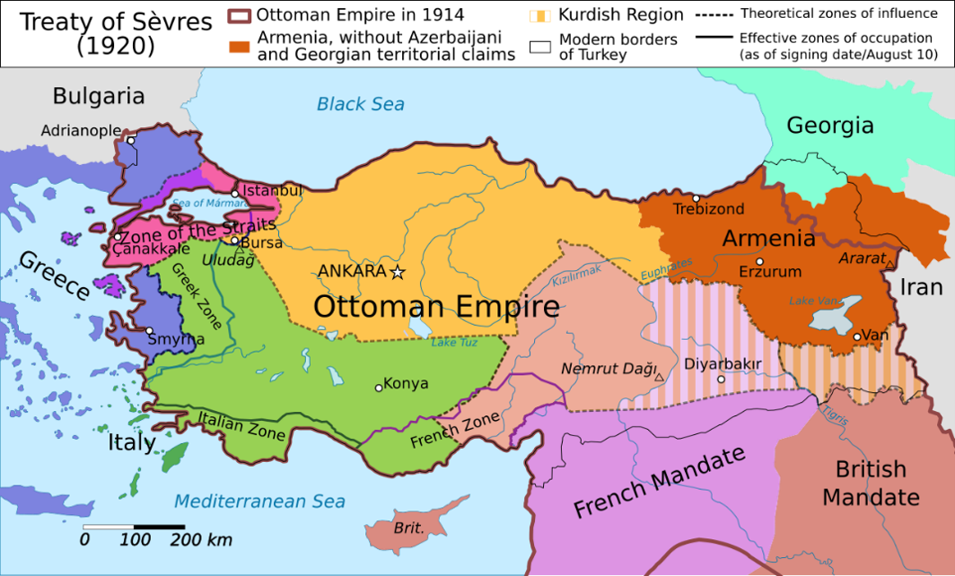
Figure 2 Digital and Popular Reproduction of the Map of the Treaty of Sevres, Wikipedia
The antidote for disintegration, on the other hand, became resistance, namely, the National Struggle after 1918. The geographical framework for the future polity and the intended borders of Turkey were determined in the process of this Struggle. This was officially declared within the National Pact in 1920. However, before the declaration of the National Pact by the Ottoman Parliament in Istanbul, the borders of Turkey had been discussed in the congresses of Erzurum and Sivas in 1919.[3] In the final declaration of the Erzurum Congress, the armistice line determined the borders of future Turkey by stating that the “Entente powers should have given up on the idea of partitioning Turkey, within the borders of 30 October 1918 when the Mudros Armistice was signed” (Goloğlu, 2008, pp.988-999). The declaration of the Sivas Congress did not differ regarding the borders; it had a direct emphasis on the Muslim majority within this line, with the clear aim of challenging the demographic and territorial claims of Armenians and Greeks.[4] Thus, it can be understood from these declarations that the territorial claim of the emerging Anatolian resistance movement was limited to the notion of the “armistice line” in principle, together with an emphasis on non-Arab Muslim unity, mostly referring to Turks and Kurds.
However, the National Pact that was declared by the Ottoman Parliament in Istanbul in February 1920 would be different from the former two declarations regarding the territorial future of Turkey. The main difference was the statement employed in the National Pact—“inside and outside” of the armistice line (hattı mütareke dahil ve haricinde)—implying that the future borders could include areas populated by the Muslims, outside of the Mudros line, yet parallel to the understanding of Wilson’s self-determination principle.[5] This created a problem for the leader of the National Struggle, Mustafa Kemal Pasha (Atatürk, hereafter), as his draft did not include the term “outside” of the armistice zone, but this was obviously changed by the parliamentarians in Istanbul. In this way, the last Ottoman Parliament had aimed to include important cities such as Aleppo, Kirkuk, and Sulaymaniyah, which were outside of the armistice zone but demographically did not reflect an Arab majority (Özkan, 2018, p.139).
These discussions regarding future boundaries were ambivalent as they also included questions of nation-building—namely, the geo-body of a future Turkey. For example, Atatürk made a speech in the Grand National Assembly in Ankara just after its opening in April 1920. In this speech, he insisted on his own understanding of borders within the armistice line, yet he included the aforementioned cities of Kirkuk and Sulaymaniyah within the Turkish territories.[6] This was actually not surprising given that Atatürk had referred to these two cities before, as part of national borders (hudud-u milli) from both military and demographic perspectives. By demography, he meant the non-Arab Muslims, Kurds and Turks together, as one of the backbones of border claims during the National Struggle. Therefore, the National Pact was not solely based on an understanding of a line but also reflected concerns about demography. In other words, it questioned whom to include in the nation in the context of the “geo-body.” It is thus understandable that while Kirkuk was regarded as part of the Turkish territory, Deir ez-Zur, which was actually inside the armistice line, was never mentioned or discussed except for during the 2010s, when Syria came to the forefront as a foreign policy matter (Kalyoncuoğlu, 2019).
During a time when the international order started to see the nation-state as the main unit based on the understanding of self-determination, the former territories of a collapsed empire posed problems to political elites. They tried to establish several norms, yet sometimes they also emphasized the concept of “geographic unity,” meaning that some places are necessary for the security of the borders, with or without fulfilling these established criteria. For example, Mosul was regarded as a “must-have,” not only because of the armistice line or non-Arab Muslim majority, but also for the future security of the territories. In parliament, while discussions about the Lausanne negotiations were made, some of the parliamentarians stated that without Mosul, the boundary line of Anatolia would start from Erzurum, implying the security problems that the state would face in Eastern and Southeastern Anatolia (Akyol & Kaplan, 2014, p.374).[7]
The multiple criteria for the formation of the National Pact signifies that the term did not have a clear definition of boundaries. Its description, on the other hand, was either challenged or interpreted differently within Turkey even in its formative phase. A good example of this ambiguity was the statement made by Atatürk himself, who frankly said that the National Pact did not draw exact boundaries, emphasizing that the boundary lines would be determined by power and capability,[8] during a parliamentary discussion about the future of the Sanjak of Alexandretta. He later reiterated his position that there was no map with fixed boundaries in the National Pact in 1923 when the developments in the Lausanne Conference were being debated in parliament.[9]
All these discussions shed light on the controversy about the future boundaries of Turkey, and more than this, about the ways of determining them. Nevertheless, the National Pact was formed as a defensive declaration to fight against the partition of Turkey for its territorial integrity. In this respect, it was a reply to the Treaty of Sevres’ map of indignity, although the latter had official annexed maps, while the National Pact was originally textual. Nowadays, the web page of the Turkish Historical Society presents a map of the National Pact, yet with no proper explanation of its origin except the title, “New National Pact Map,” supposedly published in 1920 by Hilal Publishing House (See Figure 3).
The National Pact has always been regarded as a legitimizing document or concept for the possible shape of the country. It has also included debates about the nation. As the content of the National Pact was both contentious and in flux from the beginning, it has been interpreted and re-interpreted to manifest the cartographic fears and ambitions of Turkey that would be closely related to the Turkish foreign policy agenda of the concerned time, as will be shown in the next section.
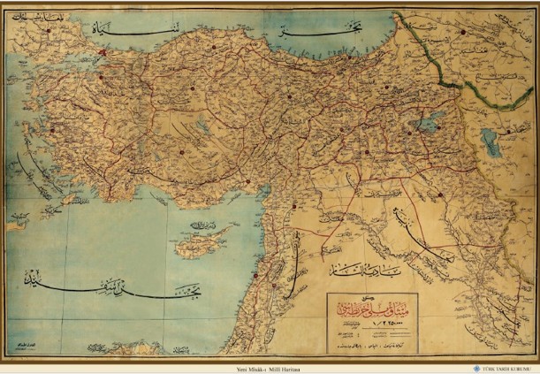
Figure 3 "Yeni Misak-ı Milli Haritası", published by Kanaat Kütüphanesi, Hilal Matbaası, Türk Tarih Kurumu.
4. The Politics of the National Pact in One Hundred Years of Turkish Foreign Policy: Case Studies
4.1. Finalizing the Map of Turkey: Interwar Foreign Policy on Mosul and Hatay
Today, it is likely that nobody can visualize a map of Turkey such as the one created in 1927, which depicts the country without its current southernmost tip, Hatay (the former Sanjak of Alexandretta) (see Figure 5). Likewise, almost no one knows about the first map of the Republic, dating back to 1923, which had hardly noticeable boundaries (see Figure 4). At first glance, one could not understand where the Turkish borders started and ended in the Southeastern part of the country. This was not surprising given that the problem of Mosul could not be resolved by the Treaty of Lausanne, signed in 1923.
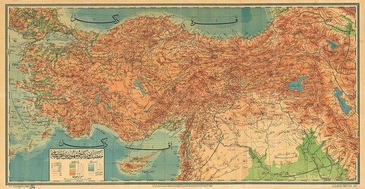
Figure 4 Map of the Republic of Turkey, 1923, Wikimedia Commons
Figure 5 Anavatan (Motherland), 1927, Alaaddin Publishing House, Wikimedia Commons
In 1923, during the ratification process of the Treaty of Lausanne in the assembly, the majority of the parliamentarians who voted “no” came from the southern cities (Uyar, 2023). This was understandable given that the problem of Mosul, to wit, the Iraqi border was deferred to the post-peace period, waiting for a resolution while the Sanjak of Alexandretta that would be called Hatay after 1936 had already been accepted within the territory of the French mandate of Syria based on the 1921 Treaty of Ankara. However, these two regions had been undisputedly included in the National Pact, based on the criteria of both the armistice line and the non-Arab majority. They were also regarded as significant for the security of Turkey. This means that the political leadership considered them as part of the geo-body of Turkey. Hence, it is not a coincidence that these two areas made up the two crucial foreign policy issues of the early Republican era. However, it should be noted that although Turkish claims were based on the understanding of the National Pact, the state did not opt to highlight the concept when orienting its foreign policy. It is another paradox that the interwar foreign policy aimed to resolve these two concrete issues, which were strictly connected to the text of the National Pact, without explicitly referring to it. This stands in contrast to other periods in Republican history where politicians discussed and reproduced the concept with no tangible foreign policy result.
The question related to the sovereignty of Mosul had been deferred in Lausanne for the sake of peace, as it had created a deadlock between Turkey and Britain in the peace conference. After Lausanne, the two countries made inconclusive negotiations, resulting in the case being sent to the League of Nations for a decision. It should be noted that Turkey claimed Mosul in the proceedings based on several reasons, such as ethnicity and strategic considerations (The Archives of the League of Nations, 1924). Turkey advanced demographic justifications consistent with the idea of a Turkish and Kurdish unity, including the security logic prevalent since the formation of the National Pact.
The League decided in favour of Iraq, which was a mandate of Britain at the time. After a brief hesitation, Turkey accepted the decision, closing the Mosul dossier, at least for the early Republican era, since Mosul was seen as a possible reason for the collapse of the newly formed regime, as many European countries had been expecting since its foundation (Barlas, 2004, pp.232-233). While Ankara was faced with the danger of another war on multiple fronts at that time, it also dealt with a series of rebellions in the Eastern cities, including the renowned Sheikh Sait Revolt (Papuççular, 2019, pp.50-54). The British involvement in which is still a point of discussion. The problem with the Iraqi border also influenced Turkish domestic politics. When the southern borders around Iraq were finalized contrary to the unclarity shown in Figure 4, the resulting rebellions demonstrated that envisioning the nation would not be as simple as what was outlined during the National Struggle, namely considering a non-Arab Muslim demography as the determinant feature of Turkey’s geo-body.
Contrary to Mosul, Turkey annexed Hatay. The region had remained under the French mandate of Syria as a result of the Ankara Treaty of 1921, even though it was part of the National Pact. When the negotiations about the future independence of Syria started in 1936, Hatay became the focal point of Turkish foreign policy since its special autonomous regime was faced with possible oblivion by France and Syria.[10] After three years of—coercive—diplomacy, Hatay became a Turkish territory in 1939. The case of Hatay is important in many respects. First and foremost, this became the only major boundary change in Republican history even though Turkey’s cartographic ambitions appeared in several periods. Second, this territorial change occurred during a period when Turkish foreign policy was most strongly associated with anti-revisionism, indicating that the ruling elite of the time could act differently for cases in which its claims were regarded as legitimate. Third, and related to the former point, while pursuing anti-revisionist regional initiatives, Turkey committed to an irredentist act without direct military clash, further turning the case into an anomaly (Gulmez, 2017). Fourth, the success of Turkey in this case was closely related to the transformation of the regional subsystem—the Eastern Mediterranean—implying that when suitable systemic conditions occur, Turkey could and/or would revise its position on its borders, as will be seen below.
Finally, the Hatay case opened Pandora’s Box with regard to the boundaries of Turkey. During the period that Turkey negotiated the future of Hatay, rumours spread about a possible claim or action on Aleppo, too. In a telegram sent to the Ministry of Foreign Affairs from Geneva in 1939, Necmettin Sadak emphasized these frequent rumours about the future of Aleppo. He also said that he was answering questions by stating that Turkey did not have any territorial case other than Hatay (T.C. Cumhurbaşkanlığı Devlet Arşivleri Başkanlığı, 1939). Although it is not possible to say that the Turkish political actors constituted a monolithic entity regarding their position on the borders, Sadak’s statement was probably justified, at least for the people who formulated the foreign policy of the time, as the ruling elite regarded Hatay as part of the National Pact as well as the Turkish nation, unlike Aleppo. Nevertheless, the annexation of Hatay in 1939 made the map of Turkey drawn in 1927 obsolete.
4.2. Cold War Fears and Ambitions: A Lesser or Greater Turkey?
The Cold War period for Turkish foreign policy started with the “1945 crisis” that was associated with the Soviet Union’s demands on Turkey for a revision of the Straits regime and rumours about a possible Soviet claim on Kars and Ardahan, the two eastern cities of Turkey.[11] This created anxiety about the territorial integrity of Turkey and reopened a discussion of the past decades, particularly the processes of negotiation and compromise with the Soviets. Through the Treaty of Moscow of 1921, the Soviet Union had formally recognized the National Pact. The treaty reflected a compromise territorially, allocating the three cities of Kars, Ardahan, and Batum between the two powers. In 1945, the deterioration of bilateral relations triggered not only concerns about security but also cartographic anxieties of Turkey under the Cold War conditions. It is probable that these anxieties were amplified with news of possible Greek claims on the Turkish islands of Gökçeada (Imbros) and Bozcaada (Tenedos) (T.C. Cumhurbaşkanlığı Devlet Arşivleri Başkanlığı, 1945), as well as rumours about a possible Syrian petition to the UN Security Council or International Court of Justice on the legality of Turkish sovereignty over Hatay (U.S. Central Intelligence Agency, 1947). In an international system that the boundaries being redrawn, this brief period full of uncertainty after WWII was formidable for Turkish foreign policy.
However, once its security was ensured through the Western alliance, the Democratic Party government started to have vague regional ambitions in the 1950s, this time through the support of its ally, the United States. In fact, the theme of “Greater Turkey” started with Soviet propaganda at first, through the broadcasts of Radio Moscow in the Arab countries (U.S. Central Intelligence Agency, 1951). According to these broadcasts, Turkey was planning to take control of Syria and Lebanon. The content of the news changed from one country to another, yet Syria remained a focal point as a former Ottoman land and as a country supported by the Soviet Union. In a similar vein, according to the Syrian communists, Turkey, which had taken the control of the Sanjak of Alexandretta, was planning a future attack against Syria and Lebanon, this time with the aid of imperialist Western countries (T.C. Cumhurbaşkanlığı Devlet Arşivleri Başkanlığı, 1951).
The problem of Syria came to the forefront with the 1957 crisis, again showing Cold War tensions and divisions. During this crisis, Turkey problematized the Soviet concentration across the border in addition to the rising impact of communism in Syria. However, according to the accounts, its focus evolved into capturing Aleppo and some parts of northern Syria within the borders of the National Pact, yet the expected move could not take place because both the US and the Soviet Union desired to decrease tensions (Bakır, 2022, pp.228-235). The intention of capturing Aleppo is not verified by the existing archival documents. However, it is still meaningful that even the rumours about Turkish cartographic ambitions reflected the Cold War divisions, as well as the international system. It is not a coincidence that Aleppo, or Syria in general, had come to the forefront rather than Mosul, or the border of then-ally Iraq.
The era of the Democratic Party was not just important to situate the vague aims of Turkey in terms of its southern boundary. On the contrary, this era brought a new dynamic to Turkish foreign policy regarding the National Pact: the Cyprus issue. Cyprus had been under the control of Britain during the late nineteenth century and officially annexed during the First World War. The Treaty of Lausanne recognized the British rule over the island that would not be a problem for Turkey until the late 1940s when the decolonization process for Cyprus started, as it was not within the scope of the National Pact or Turkish foreign policy prior to that. Cyprus, through time, would turn into a national cause in Turkey, an indivisible part of the homeland (vatan), based on the discourses of security and threats, again within the Cold War dynamics (Özkan, 2015). However, creating theses for the inclusion of Cyprus within the borders of the motherland was not an easy task for Turkish foreign policy.
Until Cyprus, Turkey’s major territorial interests had usually been related to the justification that the National Pact provided. Cyprus posed a problem to be resolved in this respect very similar to the case of the Dodecanese Islands after the end of World War II. Turkey could not intervene in the latter case properly as it was dealing with the 1945 crisis, to wit, an episode of cartographic anxiety when the sovereignty of the Dodecanese Islands changed. However, during low-profile discussions, Turkey suggested that it had transferred its sovereign rights to another power through the Treaty of Lausanne. If this status-quo changed, Turkey as the previous sovereign power would interfere, to the extent that it could reclaim the former territories (Papuççular, 2019, pp.208-209). This approach was adopted by Fatin Rüştü Zorlu, the then Turkish Minister of Foreign Affairs, in the Cyprus case as well.
However, in the parliamentary discussions, Cyprus was also discussed in relation to the National Pact in the 1960s given that several crises on the island took place. In this regard, the island was an intricate case. On the one hand, Cyprus had never been discussed or accepted within the context of the National Pact, in any of its forms. On the other hand, in the first maps of Turkey, as seen in Figure 5, Cyprus, together with the Aegean Islands, was strangely represented with the coloring of Anatolia, while other places out of the borders were left blank. However, these islands had not constituted a foreign policy matter during this era either. In the 1960s, when parliamentarians talked about the island’s future, Alparslan Türkeş, a Cyprus-born politician—and a former officer—referred to the National Pact by saying that Turkey had always hesitated to make claims about its rights outside of the borders represented in the National Pact.[12] This was a statement acknowledging that Cyprus was beyond the boundaries of the National Pact. While Türkeş resolved this problem with an emphasis on Turkish security, others came up with other ideas. For example, Celal Nuri Koç, a deputy from the ruling Justice Party (Adalet Partisi) offered a new National Pact according to the necessities of the time.[13] However, in the same session, Muzaffer Özdağ, a former officer and a deputy from the nationalist Republican Peasants’ Nation Party (Cumhuriyetçi Köylü Millet Partisi), the party also of Türkeş, tried to connect Cyprus to the National Pact in a far-fetched way. He stated that there existed a Cyprus problem because the Treaty of Lausanne failed to fulfill the National Pact.[14] This was one of the first instances that Cyprus was included in the National Pact. Today, many reproduced maps of the National Pact that can be found in the digital arena (see Figure 8) include Cyprus.
Discussions around the Cyprus issue highlight several aspects of the National Pact for Turkish foreign policy. First, nearly half a century after its declaration, the National Pact continued to be regarded as a legitimate basis for any Turkish territorial claims, as evidenced by the efforts to include the island within the boundaries of the Pact. Second, these discussions demonstrate the volatile character of the National Pact, which has proven easy to adjust according to the shifting necessities of Turkish foreign policy. Third, they reflect the dual character of Turkish cartographic anxiety, which frequently tends to connect fear to ambition. The island was considered a security threat if unified with Greece, and the only way to overcome this was regarded as Turkish domination. Such an attitude remains visible in the foreign policy of the 21st century.
4.3.(Re)Rise of Cartographic Anxiety of Turkey and the Politics of the National Pact in Turkish Foreign Policy after the Cold War
The end of the Cold War created changes in the international system associated with unipolarity under the US leadership for at least a decade. The reflection of this transformation in the Middle East was the Gulf War, which revived discussions in Turkish politics about the Iraqi border based on the Mosul question. In fact, it was the first time after the 1920s that Mosul would seriously be discussed in Turkish foreign policy in relation to boundaries. The then President, Turgut Özal, keenly wanted to open a front from the northern part of Iraq, which would be one of the reasons for a cabinet crisis in Turkish politics. During the Gulf War, the Minister of Defense and the Chief of Staff resigned. The latter, on a later date, declared that Özal had put pressure on the army to capture Mosul and Kirkuk during the crisis (Sazak, 2002). This was problematic for the Chief of Staff on the grounds that he did not trust Özal’s intention regarding the capture of these cities, nor his stance on the Kurdish issue (Uzgel, 1998, pp.322-325). According to some scholars, Özal intended to capture Mosul and to form a federal structure to solve the Kurdish problem (Ataman, 2003, pp.59-60), which could be related to the army’s suspicion. Özal’s idea was rejected not only by the army, but also by the opposition parties, as the parliamentary proceedings show. Additionally, Süleyman Demirel made a statement in a secret session of parliament about the absence of “Hatay dynamics,”[15] largely referring to the conditions of the interwar period that enabled the annexation of Hatay. This statement portrays the historical analogies being made at that moment. However, in 1995, when the PKK attacks against Turkey had reached a climax, Demirel himself pointed out that the border line between Turkey and Iraq was not suitable for the defense of Turkey and that it should be rectified (“Demirel Alarm Verdi,” 1995, p.1). Later, in the early 2000s, the left-wing politician Bülent Ecevit joined the club by explaining that annexation of Mosul was İnönü’s will.[16] These were the times in which the National Pact was also utilized to refer to the integrity of Turkey through cartographic anxiety about disintegration because of Kurdish separatism.
Özal’s time in office placed Mosul at the forefront once again and constituted a ground for debates on neo-Ottomanism in Turkish foreign policy. Although the term is largely associated with the foreign policy of the Justice and Development Party (Adalet ve Kalkınma Partisi, JDP hereafter), it originates from the Özal period (Balcı, 2021, pp.219-222). The term itself is not easy to define in a clear way, but in the context of Özal’s foreign policy, it indicated increasing relations with the “Islamic world” based on the discourse of shared cultural and historical ties. This understanding of the Ottoman past connects his era to the 21st century. JDP, on the other hand, visualized an imperial past as an alternative to the history of the nation-state project, providing a distinct way of rethinking society, its identity, and its relationship with foreign policy (Yavuz, 2020). This was clearly implying a possible change in the geo-body of Turkey. While this Ottoman euphoria resonated with positive tones in the international public opinion during the first decade of JDP rule, it turned into debates about Turkish “imperialism” mostly associated with the changing national image of Turkey and transforming regional geopolitics in the second decade of the 21st century. As a result, discussions on Turkey’s aims to control the former Ottoman territories gradually increased.
While Turkey’s ambitions were being discussed by different circles, the President of Turkey, Recep Tayyip Erdoğan, started to refer to the National Pact in specific terms in 2016. The timing was no coincidence, as Turkey had recently gone through the July 15th coup attempt, creating an “existential crisis” in both domestic and foreign policy. This also explains the increase in the number of studies dealing with anxiety in Turkish foreign policy, specifically focusing on the post-2016 period.
During this period, Erdoğan had referred to the resistance against the coup attempt as the “Second War of Independence” in one of his speeches.[17] In the same speech, he also stated that the National Pact was not realized for the southern and western borders.[18] That speech coincided with the Mosul Operation in 2016 that was held by the Iraqi government to retake the city from ISIS. However, after a brief period during which Mosul was remembered as part of the National Pact and Özal was commemorated for his unsuccessful idea of capturing Mosul during the Gulf War (Özer, 2016), the focal point of discourse on the National Pact gravitated towards Syria and the Eastern Mediterranean.
Syria has become the most emblematic case demonstrating the cartographic anxiety of Turkey, simultaneously involving fear and ambition. It represents fear on the grounds that Turkey’s attempts at peace with the Kurds came to an end in the context of controversy surrounding SDF/YPG during the Syrian Civil War (For geopolitics of the Kurdish question see Yegen, 2022). This means that the rising power of the SDF/YPG, which was regarded as an extension of the PKK by Turkey, in Northern Syria after 2014 triggered security concerns about Turkey’s own territorial integrity. Thereafter, Ankara started a series of operations both in Southeastern Anatolia and in Northern Syria. However, this cartographic fear was translated into a cartographic ambition as the statements of Erdoğan about the National Pact show. For example, in one of the speeches in 2017, he explicitly emphasized that Turkey was carrying out the National Pact through Operation Euphrates Shield.[19] He stated that the National Pact should be reclaimed given that the attacks on these borders were targeting Turkey (“Erdoğan: İdlib'de Afrin'de yapılan Misakı Milli'dir,” 2017). The National Pact, especially the parts concerning Syria, became a foreign policy discourse through which Turkey implied border revision to ensure its security. This discourse has been supported through various indirect methods. For example, in 2021, the Turkish Grand National Assembly published a book on the National Pact based on the proceedings of a conference (Alkan, 2021). Likewise, Anatolian Agency, a state news agency, published maps and commentaries on the Pact (see Figure 6) (Kalyoncuoğlu, 2019).
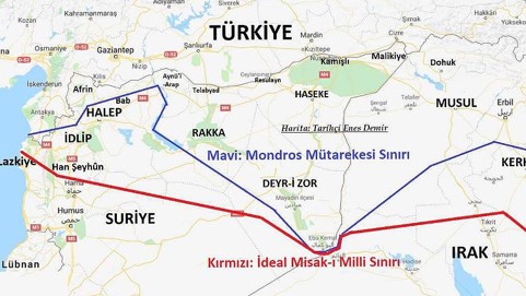
Figure 6 Map showing the alternative boundaries based on the different versions of the National Pact, Anatolian Agency
These assertions have also been supported by the popular maps that have been drawn and circulated on the web creating alternative cartographic visualizations for Turkey (Batuman, 2010, pp.230-231). Figure 7 is such an appropriated map easily reachable via Wikimedia Commons, which says that the “National Pact is the borders of Turkey accepted by the last Ottoman Parliament on January 28, 1920” (Misak-ı Milli Haritası, 2023). The statement is a historical truth but the map is not correct based on any version of the document. According to Batuman, these maps are not simply false cartographic representations, they are also important as they are referring to a document that is ideologically legitimizing and epistemologically valid (Batuman, 2010, p.230). In this sense, these maps have become a popular means for visions of an alternative geo-body of Turkey, which not only supports the idea of new boundaries but also helps envision a substitute body politic that is supported by the neo-Ottomanist ideology. It should be noted that such cartographic representations have allegedly appeared in school textbooks (see Figure 8).
Figure 7 An Example of an Appropriated Map of the National Pact, Wikimedia Commons
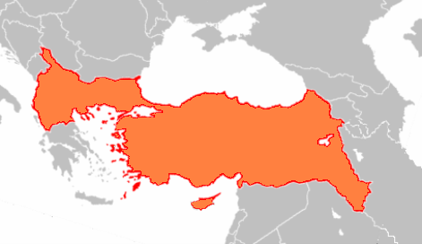
Figure 8 A National Pact Map allegedly taken from a School Textbook, Wikimedia Commons
At nearly the same time, an unusual overlap has also emerged between the ideas of the Turkish ruling elite and Abdullah Öcalan, the imprisoned ringleader of the PKK, regarding Turkey’s so-called faulty southern boundaries. While the case of Syria triggered Turkish anxiety about its territorial integrity in relation to the Kurds, with dire consequences regarding the Kurdish peace process inside the borders in addition to Turkish military operations, Öcalan was writing books about democratic confederalism, emphasizing the importance of the National Pact, which theoretically unifies the Kurds of Turkey, Iraq, and Syria (Soleimani & Shojai, 2025, pp.75-107). According to his ideas, which blend well with the neo-Ottomanist body politic, the National Pact places Iraq’s and Syria’s Kurds under Turkish control, which means a more progressive system compared to the nation-state structure (Soleimani & Shojai, 2025, p.77). It is highly debatable to what extent Öcalan’s ideas are approved by the rest of the Kurds. However, his eager position in the “peace process” that started in late 2024 and culminated in the PKK’s decision to dissolve itself in May 2025 is noticeable, creating an enigma about a possible future geo-body for Turkey.
In addition to the southern borders, another noticeable claim in discussions of the National Pact is related to the Western boundaries of Turkey. After 2015, Turkish foreign policy underwent a transformative process that emphasized the dynamics of militarization more (Mehmetcik & Çelik, 2022), as discussed in the Syrian case. It also paved the way for the securitization of Turkish foreign policy in the Eastern Mediterranean. This already existent tendency was further fostered by the failed coup attempt in 2016 in Turkey, as the so-called Eurasianist wing within the army and navy gained the upper hand in Turkish politics. The Blue Homeland strategy, or “the national pact on the seas,” which had originally been formed and developed by these groups within the navy, became a government policy and led to a more ambitious stance in the region that culminated in the 2020 Eastern Mediterranean crisis.
In fact, the Blue Homeland map is simply based on the Turkish thesis about the continental shelf in the region. It reflects a justifiable anxiety about Turkey becoming landlocked. However, the (re)formulation of the concept as the “national pact on the seas” constitutes an ambition, too. This becomes much more apparent, especially when the sovereignty of the islands has been problematized through frank statements by politicians.[20] Some of these explanations certainly targeted domestic constituency. However, Erdoğan’s photos in front of the Blue Homeland Map, for example, have foreign policy repercussions. Furthermore, as Blue Homeland, A Book of a Map and a Doctrine, which I referred to in the introduction, shows, the state is also taking steps to transform the discourses related to the National Pact, and thus the borders, through “intellectual” production. This signifies that academics are “reconsidering” the National Pact after a century, mostly emphasizing that it had not been fulfilled because of the conditions of the National Struggle era, indicating possible future aims to finalize it (Alkan, 2021).
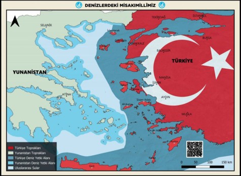
Figure 9 The Map on "The National Pact on Our Seas" prepared by Idealist Hearths and presented to Devlet Bahceli, Ülkü Ocakları
5. Conclusion
This narrative around the concept of the National Pact shows that the borders of Turkey were discussed throughout the Republican history. In other words, for more than a century, the geo-body of Turkey has been open to debate, concerning not only the country’s shape but also who may be included within these borders. While the debates themselves show continuity, especially about the optimal shape for Turkey, there are changing views about the latter. This was argumentative from the moment the National Pact was formed and discussed. It was obvious that the construction of boundaries could not be restricted to the “armistice line,” especially when there were areas inhabited by the Turks outside of that line. At the beginning of the 20th century, the solution was the non-Arab majority, especially for the problematic areas, most of the time emphasizing a common destiny between Turks and Kurds. In the 21st century, on the other hand, the emphasis on the Ottoman past, especially regarding an exaggerated view on shared history and culture with Arabs, became the background for debates on Turkey’s future geo-body. It is important to analyse the reproduced maps of the National Pact since the 2010s, particularly the borders concerning Syria, given the shifting perspectives on the geo-body.
The National Pact has always been a legitimizing document for territorial discussions in Turkish foreign policy. Its contentious and volatile character from the beginning facilitated this understanding that the content of the Pact was evaluated and re-evaluated to the degree that Turkish foreign policy necessitated. As the cases exemplified throughout this article demonstrate, the makers of Turkish foreign policy intentionally adjusted their stances on specific lines and spots in the Pact over time. Digital and popular reproductions of the maps in recent times, on the other hand, mostly offer aggrandized claims regarding the National Pact, tenuously linked to historical reality.
Overall, this article emphasized that these claims involving the National Pact reflect Turkey’s cartographic anxieties. The Pact is another historical legacy that affects the Turkish state of mind regarding its boundaries. Anxiety is employed in this article to demonstrate both fear and ambition, which are sometimes set in motion concurrently. Although this tendency seems paradoxical, it is also understandable given that the National Pact was both a statement of the National Struggle’s territorial aims and a defensive document meant to cope with the disintegration of the Ottoman Empire. In conclusion, this article was an attempt to show that debates about the boundaries in Turkish foreign policy reflect a complexity that is hardly comprehensible through conventional theoretical lenses.
FOOTNOTES
[1] For example, the renowned Turkish Historical Thesis of the early Republican Period, which claimed that the ancient Turks were the ancestors of all other races, or the Turkish thesis on the deportation of the Armenians in 1915 were produced and circulated widely by this institution. [2] The Treaty of Sèvres was the post-WWI peace settlement that was imposed upon the Ottoman Empire, predicated on the partition of the empire. Although this treaty was never implemented, it has remained a traumatic historical legacy especially regarding the fear of “disintegration.” For more information, see the following section. [3] These congresses are the initial phases to organize the National Struggle. Participants discussed the scope of the resistance movement and the needed means to aciheve its aims. After each congress, an official declaration was made about these aims and methods targeting both domestic and foreign audiences. [4] “Devlet-i Aliyye-i Osmaniye ile Düvel-i İ'tilâfiye arasında mün'akid mütârekenâmenin imzâ olunduğu fî 30 Teşrinievvel sene 334 târîhindeki hudûdumuz dâhilinde kalan ve her noktası İslâm ekseriyet-i kâhiresiyle meskûn olan Memâlik-i Osmaniye aksâmı yekdiğerinden ve câmi'a-i Osmaniyeden gayr-i kâbil-i tecezzî ve hiçbirisiyle iftirâk etmez bir küll teşkîl eder; memâlik-i mezkûrede yaşayan bi'l-cümle anâsır-ı İslâmiye yekdiğerine karşı hürmet-i mütekâbile ve fedâkârlık hissiyâtıyla meşhûn ve hukûk-ı ırkiye ve ictimâ'iyeleriyle şerâ'it-i muhîtiyelerine tamâmıyla ri'âyetkâr öz kardeşlerdir” (Özdil et al., 2021, p.52). [5] “Osmanlı Devleti’nin sadece Arap çoğunluğunun yaşadığı, 30 Ekim 1918 tarihli mütarekenin imzalanması sırasında işgal altında kalan kısımlarının mukadderatı ahalisinin serbestçe vereceği oylara göre belirleneceğinden adı geçen mütareke hattının içinde ve dışında dinen, ırken, emelen birleşmiş, karşılıklı sevgi ve fedakârlık hisleriyle dolu, örfî ve içtimaî haklarıyla mahallî şartlara tamamen riayetkâr Osmanlı-İslâm ekseriyetiyle meskûn bulunan kısımların tamamı hakikaten ve hükmen hiçbir sebeple ayrılma kabul etmez bir bütündür.” (Türk Tarih Kurumu, 2020). [6] “Vatanımızın hududu olacak bu hududu ihtimaldir ki, teferruatıyla bilmeyen arkadaşlarımız vardır. Bunu: Şark hududuna Elviye-i Selaseyi (Kars, Ardahan ve Batum) dâhil ederek tasavvur buyurunuz.Garp hududu Edirne’den bildiğimiz gibi geçiyor. En büyük tebeddülat, Güney hududunda olmuştur. Güney hududu İskenderun güneyinden başlar. Halep ile Katma arasından Cerablus Köprüsü'ne müntehi olur bir hat ve Şark parçasında da Musul vilayeti, Süleymaniye ve Kerkük havalisi ve bu iki mıntıkayı yekdiğerine kalbeden hat. Efendiler; bu hudut, sırf askeri mülâhazat ile çizilmiş bir hudut değildir, hudud-u millî'dir” (As cited in Özkan, 2018, p.141). [7] The parliamentarians implied that Britain would flare Kurdish nationalism in the region if Mosul were not to be taken. [8] “O başka bir meseledir. Misâk-ı Millîmizde muayyen ve müspet bir hat yoktur. Kuvvet ve kudretimizle tespit edeceğimiz hat, hatt-ı hudud olacaktır” (Budak, 1998, p.255). [9] “…haritası mevcut bir sınır yoktur” (Akyol & Kaplan, 2014, p.393). [10] It should be noted that Hatay came to the forefront of Turkish foreign policy in 1936, but Turkey had followed “diaspora politics” targeting the Turkish community in the region since the 1920s, showing engagement with the former Ottoman territories. (Papuççular, 2020). [11] Whether the Soviet Union indeed claimed Kars and Ardahan is a major debate in Turkish foreign policy scholarship. It should be noted that while Moscow did not officially demand the two cities, the vague claims and keen propaganda it directed towards them created much anxiety in Turkey about the changing international order. (see Papuççular, 2023, pp.93-100). [12] “Memlekette millî misak ile çizilmiş sınırların dışında bu devletin ve bu milletin hakları ile ilgili bir mesele üzerinde konuşmak, söz söylemek, talepte bulunmak daima ürküntüyle, çekinilerek karşılanan bir durum olmuştur” (Millet Meclisi Tutanak Dergisi, 1969, p.445). [13] “Bunlarca millî misakı da yanlış anlaşıldı. Bugünkü sert realitelerin karşısında Türk Milleti evvel Allah'ın izniyle yeni bir millî misak çizecektir. Bundan da müsterih olun. Millî misak günün şartlarına göre doğar. O millî misak da günün şartlarına göre değişir merak etmeyin. Yakında bunu inşallah görürsünüz” (Millrt Meclisi Tutanak Dergisi, 1966, p.267). [14] “Bugün Kıbrıs meselesi varsa millî misak da gerçekleşmediği içindir” (Millet Meclisi Tutanak Dergisi, 1966, p.251). [15] “Ortada bir Hatay konjonktürü yoktur” (TBMM Tutanak Dergisi, 1990, p.11). [16] “İsmet İnönü, genel sekreteriyken beni çağırıp ‘Şartlar elvermiyordu biz alamadık. Şartlar elverdiğinde Türkiye’nin Musul’u topraklarına katması uygun ve gerekli olacaktır. Bunu hatırından çıkarma” (Görmüş, 2024). [17] “15 Temmuz gecesi darbecilerin karşısına dikilen kahraman vatandaşlarımız ancak istiklaline karşı çıkarsa güvenli bir geleceği olacağını biliyor.Bunun için biz 15 Temmuz'a 2. Kurtuluş Savaşı diyoruz.” (“Cumhurbaşkanı Erdoğan 28. Kez Muhtarları Ağırladı”, 2016). [18] “Maalesef hem batı hem de güney sınırlarımızda Misak-ı Milli hedeflerimizi koruyamadık. Dönemin şartları itibarıyla bu durumu mazur görenler, göstermeye çalışanlar olabilir. Bu yaklaşımı bir yere kadar mazur görmek mümkündür. Asıl vahimi, zorunluluklardan kaynaklanan bu durumu esas olarak kabul edip kendimizi tamamen bu kabuğun içine hapsetme anlayışıdır. Biz işte bu anlayışı reddediyoruz. Türkiye'yi 1923'ten beri böyle bir kısır döngüye hapsedenlerin amacı coğrafyamızdaki bin yıllık varlığımızı, Selçuklu ve Osmanlı geçmişimizi bize unutturmaktır.” (“Cumhurbaşkanı Erdoğan 28. Kez Muhtarları Ağırladı”, 2016). [19] “Biz Kurtuluş Savaşımıza başlarken ilan ettiğimiz Misak-ı Millimize de sahip çıkamadık. Suriye ve Irak'taki gelişmelerde zaman zaman dillendiriyorum. Biz Misak-ı Millimize yeniden sahip çıkmak zorundayız diyorum. Eğer o hudutlar içinden ülkemize saldırılar oluyorsa buradan buyurun devam edin deme lüksümüz yoktur. Gereğini, gerektiği şekilde yapma zorunluluğumuz var. Fırat Kalkanı Harekatı budur, İdlib'de yapılmakta olan budur. Açıklıyorum, Afrin'de yapılmakta olan da budur. Orada olanlar bizim akrabamız, onların değil. Öyle ise akrabalarımızın hukukuna da sahip çıkmak zorundayız” (“Erdoğan: İdlib'de Afrin'de yapılan Misakı Milli'dir”, 2017). [20] “Biz 780 bin metrekareye, 20 milyon metrekarelerden geldik. 2016 yılında 1923 psikolojisiyle hareket edemeyiz. Maalesef hem batı hem de güney sınırlarımızda Misak-ı Milli hedeflerimizi koruyamadık. Dönemin şartları itibarıyla bu durumu mazur görenler, göstermeye çalışanlar olabilir. Bu yaklaşımı bir yere kadar mazur görmek mümkündür” (“Erdoğan: Misak-ı Milli Hedeflerimizi Koruyamadık”, 2016). In 2025, governing partner MHP’s Bahceli made a statement about the Dodecanese, again fuelling a debate. “Türkiye On İki Ada'sız yaşasa bile, On İki Ada'nın Türkiyesiz yaşaması ham bir hayaldir.” (“Bahçeli’nin On İki Ada Çıkışı,” 2025).